LegendPeeps
Home Apps Maps & Navigation onX Offroad: Trail Maps & GPS
onX Offroad: Trail Maps & GPS

onX Offroad: Trail Maps & GPS

3.53
|
V26.14.0
|
1M+
onX Offroad: Trail Maps & GPS screenshot onX Offroad: Trail Maps & GPS screenshot onX Offroad: Trail Maps & GPS screenshot onX Offroad: Trail Maps & GPS screenshot onX Offroad: Trail Maps & GPS screenshot onX Offroad: Trail Maps & GPS screenshot onX Offroad: Trail Maps & GPS screenshot onX Offroad: Trail Maps & GPS screenshot

App Information

Category Maps & Navigation
Developer onXmaps
Version 26.14.0
Content Rating Everyone
Price Free
Min Android 8.0
Updated Apr 24, 2026

Description

Navigate off-road and find the trails you’re looking for with onX Offroad. GPS mapping, 3D trail maps, and compass navigation — discover what’s open nearby or explore something new with ease.

Filter trails by accessibility for 4x4, SxS, dirt bikes, moto, ATV/Quads, Overland, and snowmobiles. Identify free camping areas in National Forests using USFS verified data with our Motorized Dispersed Camping Layer. View property lines, private landowner information, and acreage right in the app.

Uncover new desert trails or use onX Offroad to access thousands of miles of snowmobile trail information across the country. Switch from Dirt to Snow Mode depending on your adventure. Access a GPS navigation tool that lets you stay connected. Know where you'll have cell service with AT&T, Verizon, and T-Mobile coverage maps.

Get GPS directions from the tarmac to the trails with turn-by-turn navigation and sync onX Offroad with Android Auto. Save Offline Maps to your phone or tablet. Find trailheads, trailer parking, non-ethanol fuel stations, campgrounds, and more.

Adventure starts where the pavement ends. Go where other maps can’t with onX Offroad.

onX Offroad Features:

▶ OHV Trails & Map Layers
• Find trails for your activity – SxS, 4x4, ATV, dirt bikes, snowmobiles, and more
• Toggle map layers for info on weather, land boundaries, and cell service
• Navigate off-road and identify cell coverage areas for AT&T, Verizon, and T-Mobile
• Monitor wildfires and drifting smoke with data from the NIFC and NOAA

▶ Offline Navigation & Route Builder
• View trail conditions, including difficulty ratings, and open/close dates
• Save Offline Maps without losing interactive land and trail data
• Get off-road turn-by-turn directions with voice commands. Sync with Android Auto
• Map routes that automatically snap to roads and trails

▶ Trip Tracker & Recreation Points
• Find camping spots that are legal and free along motorized trails in National Forests
• Track distance, location, speed or elevation. Save and share trips with friends
• Add Waypoints to mark campsites, fuel stations, fishing access, and more
• Customize maps by marking recreation points, rock crawls or obstacles

▶ Nationwide Property Lines (Limited by Membership)
• GPS navigation and versatile map imagery – 3d, topo, satellite or hybrid
• Access public and private land ownership information across the nation
• Identify National Forest, BLM, National Park land and more

Download onX Offroad and experience a trusted planning, mapping, and navigation app that always gets you home safely.

▶ Free Trial
Start a trial for free when you install the app. Experience the difference of a premier off-roading tool and plan your next adventure.

▶ Offroad Memberships:
Enjoy our premium features with an onX Offroad membership. Roam in parts unknown with property maps, cell coverage info, and industry brand discounts.
• 650K+ miles of motorized roads and off-road trails
• Trails for 4x4, Side-by-Side, dirtbikes, dual sport, ATV, Quads, Overlanding, and snowmobiling
• 852M acres of public land across the U.S.
• 24K topographic maps and 3D maps for the entire U.S.
• Save Offline Maps for navigation without cell service

▶ Government Information & Data Sources
onXmaps, Inc. does not represent any government or political entity, though you may find various links to public information within our services. For more information on any government information found within the services, click on the associated .gov link.
• https://data.fs.usda.gov/geodata/
• https://gbp-blm-egis.hub.arcgis.com/
• https://www.arcgis.com/home/group.html?id=00f2977287f74c79aad558708e3b6649#overview

▶ Terms of Use: https://www.onxmaps.com/tou

▶ Privacy Policy: https://www.onxmaps.com/privacy-policy

▶ Feedback: If you have any trouble or have an idea of what you’d like to see in the app next, please contact us at [email protected]. We’d love to hear from you.

Downloads

V26.14.0

Size: 186.22 MB

Updated: 2026-04-24

User Reviews

3.53
5K+ Reviews
5
51%
4
10%
3
5%
2
8%
1
26%
Matt V
Apr 27, 2026

I can't figure out how to view/manage my subscription, so I guess I'll just cancel. The app says go to the website. The website just has a useless Zen Desk that says go to the app.

Mike Bosley
Apr 27, 2026

Indispensable for work and for fun. Customer service has also been great.

Jeff Sheets
Apr 25, 2026

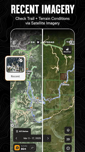
still having issue with brand new s25+ and the map sputtering along. used to be smooth with an older phone, now it jumps 10-20 feet at a time

John Iberlin
Apr 24, 2026

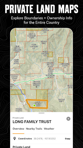
I really wish my content would stop disappearing. I've driven thousands of mapped miles. Now, about 3-4 days out of each week, they vanish. Super frustrating considering I'm trying to help you guys map trails correctly. Most of the trails you have in Wyoming are completely wrong. Trespassing can get you in a world of hurt in Wyoming. So if we could start displaying trails correctly. No one will end up discussing dinner options the Wyoming version of Mick Taylor. (not the guitarist)

Jerry Roberts
Apr 20, 2026

awesome

G Q
Apr 19, 2026

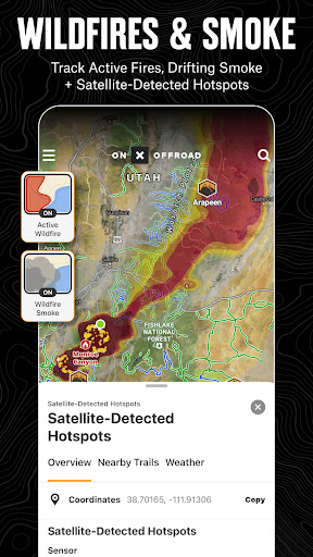
Elite member here, It's a love/hate relationship with this app. So much potential with so many great features. When it works, I'm creating all sorts of fun routes to tackle on my moto. When it's not working, I'll be 30 minutes or longer into building a route and the app malfunctions or recently, just crashes and I lose all my waypoints and route altogether. To the devs, please fix this issue. Maybe I will try unselecting app features like historic wildfire and private property lines? Thank you!

Andy Rowe
Apr 19, 2026

good maps and great customer service

Mark Kalenevitch
Apr 18, 2026

I go off map all the time but it's nothing like this

Jeremy Bitting
Apr 18, 2026

great app

Justin Taylor
Apr 18, 2026

At start up, I answered too many customization questions, wondering when it's over, just to find out it's paid app larping as a free app.