LegendPeeps
Home Apps Sports onX Backcountry Trail Maps GPS
onX Backcountry Trail Maps GPS

onX Backcountry Trail Maps GPS

4.37
|
V26.14.0
|
500K+
onX Backcountry Trail Maps GPS screenshot onX Backcountry Trail Maps GPS screenshot onX Backcountry Trail Maps GPS screenshot onX Backcountry Trail Maps GPS screenshot onX Backcountry Trail Maps GPS screenshot onX Backcountry Trail Maps GPS screenshot onX Backcountry Trail Maps GPS screenshot onX Backcountry Trail Maps GPS screenshot

App Information

Category Sports
Developer onXmaps
Version 26.14.0
Content Rating Everyone
Price Free
Min Android 8.0
Updated Apr 24, 2026

Description

Discover new trails for hiking and mountain biking. onX Backcountry features 650,000+ miles of trails, 300,000+ rock climbs, and 4,000+ ski routes. Whether you’re scouting new terrain or navigating maps in the field, onX Backcountry is the ultimate app for offline outdoor recreation.

Plan your hiking, mountain biking, and skiing activities with trustworthy data. LiDAR topographic maps, GPS tracking, and Recent Satellite Imagery help you navigate confidently in unknown terrain. 3D offline terrain and land ownership maps let you know exactly what’s ahead.

Map out custom routes seamlessly and choose your own adventure with activity-specific Map Modes. Toggle Map Layers to show nearby hazards such as wildfires or avalanches. View localized weather, study distance, and visualize elevation gain. Access a reliable offline GPS mapping app, built for remote trails and navigation.

Download 3D maps for offline use and leave a breadcrumb trail with Tracker to measure key trip stats. Review Slope Angle and Slope Aspect to evaluate the steepness and direction of terrain. Navigate summer trails, backpacking trips, or winter ski tours all in one outdoor app.

A great day in the backcountry starts with a better map. Go farther today with onX Backcountry.

onX Backcountry Features:

▶ Ultimate GPS Map App for Outdoor Pursuits
• View trail maps in 3D, LiDAR topo, satellite imagery or hybrid to visualize terrain
• Hiking, mountain biking, and skiing become easier with custom map routes
• GPS tracking to know where you came from and share your trip
• Set Waypoints and access data on Slope Angle, Slope Aspect, and Trail Slope

▶ Map Modes for Every Adventure
• Hiking – Trail lengths, difficulty levels, elevation, and real-time GPS
• Mountain biking – Biking paths, difficulty ratings, trail conditions, and elevation
• Backcountry skiing & snowboarding – Slope angles, SNOTEL data, and ATES layers
• Rock climbing – Climbing routes, climb types, GPS tracking, and user reviews

▶ Navigate Offline without Cell Coverage
• Download 3D maps with interactive trail data. Turn your phone into a handheld GPS
• Track your location and follow the blue dot to get back to your starting point
• Measure hiking, biking, or skiing stats to see where you’ve been
• View distance or elevation gain in seconds as you navigate in the field

▶ Scout Ahead & Stay Safe on your Trip
• Use the compass to find your location and orient yourself
• Access localized weather conditions, 7-day weather forecasts, and hourly wind data
• Hike confidently with Trail Reports. Submit current conditions and trail closures
• Plan ahead with ATES, wildfire, air quality, and smoke density layers

Your Four-Season Outdoor App
onX Backcountry brings everything you need into one place. Download today and access the most detailed, dynamic, and reliable maps for the backcountry.

▶ Free Trial
Start a Premium or Elite trial for free when you install the app. Maximize your backcountry experience and access all of our best features for seven days.

▶ Premium & Elite Features
• 650,000+ miles of running, hiking, backpacking, skiing, and mountain bike trails
• 4,000+ backcountry skiing lines with guidebook descriptions
• 300,000+ rock climbing routes with approach trails
• Offline 3D maps help you navigate without cell service
• 24K topographic maps and 3D maps for the entire U.S
• 985 million acres of Public Land across the U.S.
• 550,000 Recreation Icons: Trailheads, backcountry cabins, campgrounds, and more
• Map data sourced from USFS, BLM, and NPS
• Private Land Layer (ELITE ONLY): Property maps, land boundaries, land ownership, and acreage
• Recent Imagery (ELITE ONLY): Detailed satellite imagery from the past two weeks

▶ Terms of Use: https://www.onxmaps.com/tou

▶ Privacy Policy: https://www.onxmaps.com/privacy-policy

▶ Feedback: If you have any trouble or have an idea of what you’d like to see next, contact us at [email protected].

Downloads

V26.14.0

Size: 184.38 MB

Updated: 2026-04-24

User Reviews

4.37
2K+ Reviews
5
78%
4
4%
3
6%
2
1%
1
11%
Valerie Peronto
Apr 27, 2026

most horrible app ever do not download it. me and my son were going to hike trails. I downloaded the app. it didn't outline the trails we were looking for I uninstalled it after 5 minutes so they start billing me 29.99 and I never even used it I looked at it for 2 seconds and then I get text message from Google saying I owe for the subscription. did chat and Google handled it for me. thank you pay pal and Google

Chris
Apr 26, 2026

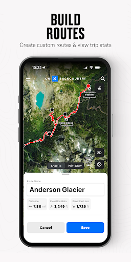
Good for finding established trails and tracking. I'm probably not the target market for this one, as I'm always looking to build my own routes. The route planner is clunky. It doesn't let you measure certain legs on a route or double back to a fork and go another direction while planning, has limited elevations when not on established trails. I'll be going back to onX Hunt and hoping for some more accurate and grainular route planning.

michael recupero
Apr 23, 2026

Great app for hiking with dogs , good layout easy to understand , GREAT professional customer service

Carl Duckworth
Apr 23, 2026

learning now

LeRoy Kinder
Apr 21, 2026

Great for the trails. These guys continue to produce the best trail/hunting apps

Leona Loftis
Apr 19, 2026

love it.

Casey
Apr 16, 2026

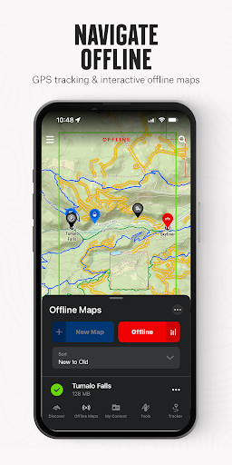
can you add a setting to switch offline map cache to SD card. please also make Appalachian trail maps contiguous as one. better easier offline support for the trail would be great, focus in on cache for the surrounding trail itself rather than big blocks around chosen by hand. thanks. also, 4g ram phone with 4g ramboost seems to lag when zoomed out.

KK
Apr 15, 2026

caltopo has more features for a cheaper subscription.

Brandon Walters (Swiftsamurai87)
Apr 11, 2026

really detailed map

Brian Engstrom
Apr 10, 2026

Great customer service and qwick to respond also