App Information
| Category | Travel & Local |
| Developer | Voice Recording |
| Version | 2.1 |
| Content Rating | Everyone |
| Price | Free |
| Min Android | 8.0 |
| Updated | Apr 21, 2026 |
Description
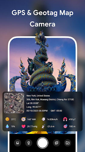
The GPS Camera Map App lets you take photos with real-time location, date, and time stamps directly displayed on your images. Whether you’re traveling, inspecting sites, or recording fieldwork, this app helps you document every moment with accurate geographic and environmental data.
With GPS Camera Map, you can instantly capture photos while viewing a live map with integrated location data. Easily access your location's latitude, longitude, and other details. You can also manually input location data and view saved locations for easy reference.
💥Key Features:
◆ Precise Location Tagging: Automatically add GPS coordinates (latitude and longitude), address, date, time, and GMT information to your photos.
◆ Map Integration: Displays a live Google Map preview with a pinpointed location marker on every image.
◆ Weather & Environment Data: Captures temperature, humidity, pressure, altitude, direction, wind speed, and magnetic field readings in real time.
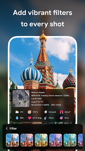
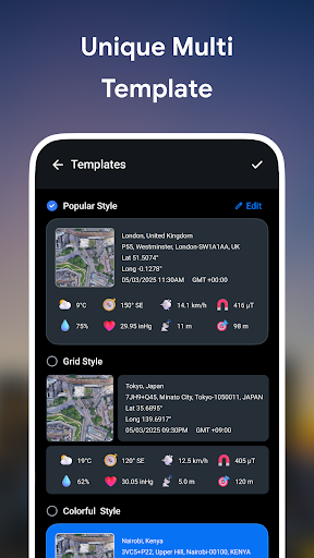
◆ Multiple Templates: Choose from various stylish templates, including Popular, Grid, or Colourful, to present your photos in a professional and visually appealing way.
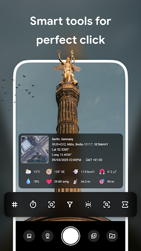
◆ Easy Editing: Customize your template, stamp format, and display layout before saving or sharing.
◆ Geotagging: Automatically tag your photos with GPS coordinates, ensuring you always know where and when each photo was captured.
◆ Professional Use: Perfect for surveyors, engineers, real estate agents, travellers, construction workers, and outdoor professionals.
◆ Intuitive Interface: Enjoy a user-friendly and intuitive interface that makes it easy to navigate, capture, and manage your location-tagged photos without any hassle.
✨Why Choose GPS Camera Map?
Whether you're capturing your travels, field research, or professional documentation, GPS Camera Map is the perfect app for adding accurate location details to your photos. Enhance your photographic experience with precise geotagging and environmental data.
📱Perfect For:
● Travelers capturing their journeys with GPS data
● Surveyors and engineers needing location-based photo records
● Real estate agents requiring location info for listings
● Construction workers and outdoor professionals tracking project progress
📲Download GPS Camera Map today and take your photos with accurate location and environmental details.
With GPS Camera Map, you can instantly capture photos while viewing a live map with integrated location data. Easily access your location's latitude, longitude, and other details. You can also manually input location data and view saved locations for easy reference.
💥Key Features:
◆ Precise Location Tagging: Automatically add GPS coordinates (latitude and longitude), address, date, time, and GMT information to your photos.
◆ Map Integration: Displays a live Google Map preview with a pinpointed location marker on every image.
◆ Weather & Environment Data: Captures temperature, humidity, pressure, altitude, direction, wind speed, and magnetic field readings in real time.
◆ Multiple Templates: Choose from various stylish templates, including Popular, Grid, or Colourful, to present your photos in a professional and visually appealing way.
◆ Easy Editing: Customize your template, stamp format, and display layout before saving or sharing.
◆ Geotagging: Automatically tag your photos with GPS coordinates, ensuring you always know where and when each photo was captured.
◆ Professional Use: Perfect for surveyors, engineers, real estate agents, travellers, construction workers, and outdoor professionals.
◆ Intuitive Interface: Enjoy a user-friendly and intuitive interface that makes it easy to navigate, capture, and manage your location-tagged photos without any hassle.
✨Why Choose GPS Camera Map?
Whether you're capturing your travels, field research, or professional documentation, GPS Camera Map is the perfect app for adding accurate location details to your photos. Enhance your photographic experience with precise geotagging and environmental data.
📱Perfect For:
● Travelers capturing their journeys with GPS data
● Surveyors and engineers needing location-based photo records
● Real estate agents requiring location info for listings
● Construction workers and outdoor professionals tracking project progress
📲Download GPS Camera Map today and take your photos with accurate location and environmental details.
User Reviews
4.12
168+ Reviews
5
65%
4
8%
3
10%
2
6%
1
11%
Daniel Saavedra
Apr 29, 2026
no good, it doesn't work
Roel jr Loredo
Apr 28, 2026
Good app
Abdul Ghaffar Ghaffar
Apr 27, 2026
very nice app
Jadhav p s
Apr 26, 2026
worst tooooo much adds
Mack Smith
Apr 26, 2026
easy too use
Pushmen
Apr 25, 2026
very good.
Veronica Shipleyduncan
Apr 23, 2026
finds where I need to go
simon
Apr 20, 2026
good 👍
Siva Screen's
Apr 20, 2026
nice
Ramesh Singh
Apr 19, 2026
gatiya app
You Might Like
Hopper: Hotels, Flights & Cars
4.56
10M+
Hotels.com: Travel Booking
4.80
50M+
Disneyland®
4.55
5M+
Booking.com: Hotels & Travel
4.80
500M+
My Disney Experience
4.50
10M+
Enterprise Car Rental
4.63
5M+
Amtrak
4.35
5M+
Six Flags
3.87
5M+
Expedia: Hotels, Flights, Cars
4.81
50M+
United Airlines
4.70
10M+